Jump to
Overview
The use of space technology represents a transformative approach to harnessing space-based assets, data, and infrastructure to deliver essential services on Earth and beyond. This extends across numerous domains, including civil, commercial, scientific, and security fields. At its core, space technology offers three irreplaceable advantages that redefine our capabilities:
- Global Perspective: Enabling a planetary-scale view that enhances our understanding of environmental and societal trends.
- Persistent Presence: Ensuring continuous observation and data collection around the clock, which is vital for timely decision-making and response.
- Independence from Ground Infrastructure: Allowing operations without the constraints of terrestrial limitations, fostering flexibility and reliability.
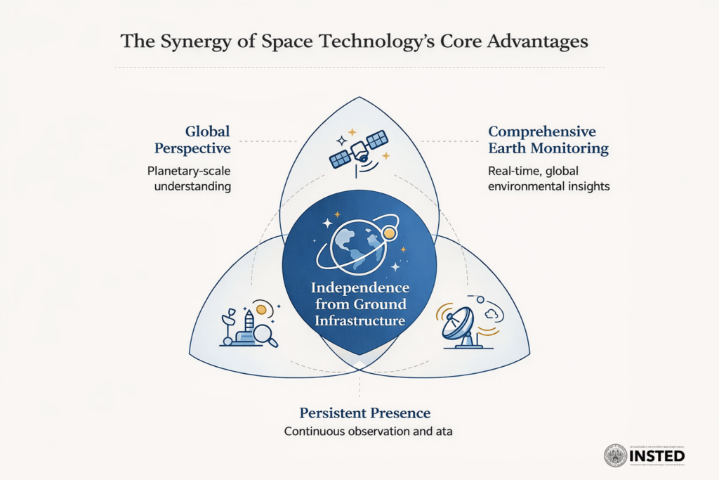
The Synergy of Space Technology’s Core Advantages
It is important to recognize that space is not merely a sector; it serves as a vital horizontal enabling layer across various industries and disciplines. The essence of space technology lies not in venturing away from Earth, but rather in deepening our understanding, protection, and sustenance of life on our planet. In the absence of space technology, societies face blindness, fragmentation, and reactive governance. Conversely, with the integration of space technology, we cultivate awareness, resilience, and a forward-thinking mindset, poised to meet the challenges of tomorrow. Let us embrace this potential and foster a future grounded in knowledge and innovation.
National Defense and Security
Intelligence, Surveillance, and Reconnaissance (ISR)
Space-based Intelligence, Surveillance, and Reconnaissance (ISR) represents a transformative capability, serving as the persistent, wide-area, multi-domain sensing and data fusion backbone that delivers early warning, real-time situational awareness, and decision superiority across land, sea, air, cyber, and electromagnetic domains. Leveraging advanced satellite payloads, sensor integration, and secure communications, space-based ISR systems enable rapid detection, tracking, and assessment of dynamic threats and activities on a global scale.
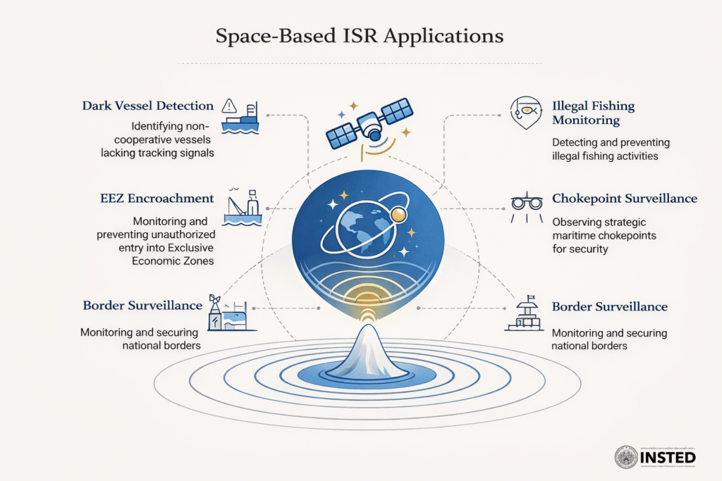
Space-Based ISR Applications
Key Technical Use Cases:
- Dark vessel detection (non-cooperative targets lacking AIS)
- Illegal fishingand/ transshipmen monitoring
- Exclusive Economic Zone (EEZ) encroachment detection
- Strategic chokepoint surveillance (e.g., Malacca and Andaman Sea)- Pre-crisis force posture and activity awareness
- Border surveillance
Space-based ISR is not merely a collection of sensors—it is the neural network of modern defense architectures, empowering nations to anticipate, adapt, and respond with unprecedented agility and precision. By integrating technical excellence with a vision for national security, space-based ISR systems inspire a new era of resilient, adaptive, and globally connected defense and intelligence solutions.
Private Secure Networks (PSNs) and Tactical Data Links (TDLs)
Private Secure Networks (PSNs): Dedicated, mission-owned communication infrastructures engineered to deliver robust confidentiality, integrity, availability, and operational control for military and national security applications. Unlike public internet, commercial mobile networks, or best-effort data services, PSNs are architected for end-to-end security, assured service quality, and command sovereignty—enabling defense organizations to maintain secure, resilient connectivity in dynamic and contested environments. PSNs empower mission planners and operators with uncompromised control and assurance, forming the backbone of trusted information exchange in the modern security landscape.)
Tactical Data Links (TDLs): TDLs are standardized, time-critical data exchangeprotocols optimized for the real-time dissemination of situational awareness, command, and control information between distributed military platforms and units. These highly structured links are engineered for low latency, high reliability, and resilient performance under hostile conditions—including electronic jamming, deception, and intermittent connectivity. By enabling synchronized action and a shared operational picture, TDLs elevate the tempo and effectiveness of joint and combined operations, even in the most complex threat environments.
Together, PSNs and TDLs serve as the digital nervous system of advanced defense architectures—delivering secure control and shared truth to enable rapid, coordinated, and adaptive responses under uncertainty. Their integration with space-based assets inspires a paradigm shift in national security, unlocking new levels of agility, resilience, and mission assurance.
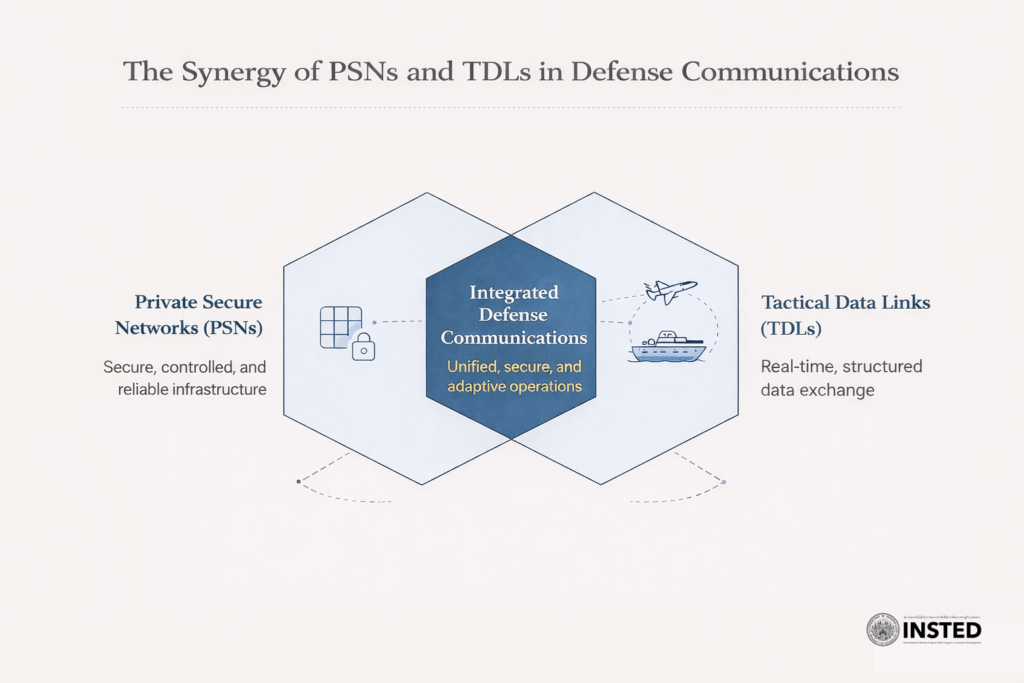
The Synergy of PSNs and TDLs in Defense Communications
Key Technical Use Cases:
- Maritime Domain Awareness (space-enabled surveillance and tracking)
- Air Defense & Early Warning
- Joint & Combined Operations- Disaster Response & Humanitarian Assistance/Disaster Relief (HADR, dual-use)
- Space Operations & Space-based ISR
By harnessing cutting-edge communications technology and integrating terrestrial and space segments, PSNs and TDLs provide the foundation for a more secure, informed, and responsive future.
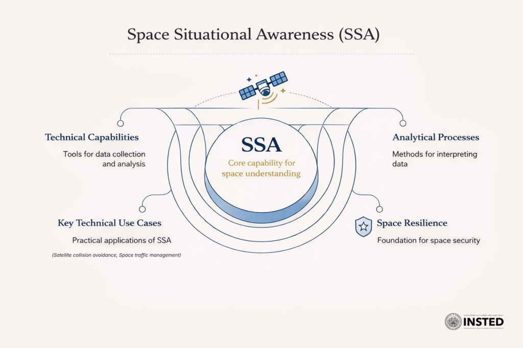
Space Situational Awareness (SSA)
Space Situational Awareness (SSA) encompasses the technical capabilities and analytical processes required to detect, track, characterize, understand, and predict the behavior of objects and activities in Earth’s orbital environment. SSA is fundamental for protecting valuable space assets, ensuring mission continuity, and empowering informed, timely decision-making in both civilian and defense sectors. At its core, SSA provides answers to critical questions: What objects are in space? Where are they? What are their trajectories and functions? What actions are they likely to take next? Do they pose any risk to national or commercial interests?
SSA
Key Technical Use Cases:
- Satellite Collision Avoidance: Preventing in-orbit collisions through precise tracking and predictive modeling.
- Protection of Military Space Services: Safeguarding communication, navigation, and surveillance satellites from interference or attack.
- Early Warning of Hostile Space Behavior: Detecting and characterizing actions that may threaten operational security or national interests.
- Space Traffic Management (STM): Coordinating the safe, efficient movement of increasing numbers of satellites and debris in congested orbital domains.
- Attribution and Strategic Signaling: Identifying actors and intent behind space activities for deterrence and diplomatic engagement.
- Support to Space-Based ISR Missions: Enhancing the reliability and effectiveness of Intelligence, Surveillance, and Reconnaissance (ISR) from orbit.
SSA is not merely a technical enabler; it is the foundation of space resilience, attribution, and strategic confidence. With robust SSA, nations and organizations can anticipate threats, protect critical infrastructure, and inspire confidence in the continued exploration and utilization of space.
Disaster Prevention and Mitigation
Flood and Coastal Monitoring
Space-based Flood and Coastal Monitoring leverages an integrated suite of multi-sensor satellite platforms, advanced geospatial analytics, and real-time data processing pipelines to deliver actionable intelligence on inland flooding, coastal inundation, erosion, and storm-surge hazards. By fusing radar, optical, and thermal data streams, these systems provide persistent, wide-area coverage regardless of weather or time of day—empowering agencies to detect, monitor, and predict complex hydrological events with unprecedented accuracy and timeliness. This technical capability is not only scalable and politically neutral, but also transformative: it underpins dual-use civil–military platforms, strengthens disaster resilience, and drives smarter, faster response at national and local levels.
Key Technical Use Cases:
- Civil / Government (e.g., Royal Irrigation Department: Real-time flood mapping, early warning dissemination, and resource allocation.
- Disaster Management Authorities: Rapid situational awareness and dynamic response coordination for flood and coastal emergencies.
- Military / Security (Dual-Use): Operational planning, infrastructure protection, and humanitarian support missions.
By integrating cutting-edge space assets with ground-based decision systems, space-based flood and coastal monitoring inspires a new era of data-driven disaster risk reduction—protecting communities, economies, and the environment from escalating climate threats.)
Wildfire Monitoring
Space-based wildfire monitoring leverages advanced Earth observation satellites equipped with multi-spectral and thermal sensors to detect, characterize, track, and forecast wildfires with high temporal and spatial resolution. These systems integrate data on thermal anomalies, smoke and aerosol dispersion, vegetation condition, and key environmental drivers such as wind, humidity, and drought to deliver continuous, borderless surveillance—even in remote or inaccessible regions.
Key Technical Use Cases:
- Early Ignition Detection: Enables rapid identification of ignition points for immediate response and containment—where every minute is critical.
- Fire Behavior & Spread Forecasting: Supports dynamic modeling of fire intensity, direction, and evolution to inform proactive disaster management.
- Disaster Response & Command Support: Provides real-time situational awareness for coordinated emergency response and command operations.
- Critical Infrastructure Protection: Safeguards essential assets—such as power lines and transport corridors—from fire-related threats.
- Environmental, Legal & Insurance Applications: Facilitates comprehensive burn scar mapping, air quality assessment, and regulatory compliance verification.
Wildfire monitoring from space transcends routine Earth observation. It is a mission-critical, multi-sensor decision-support system empowering societies to mitigate risk, protect lives and assets, and inspire innovation in climate resilience and disaster preparedness.
Logistics & Transportations
Space-based logistics and transportation harness the power of satellite infrastructure and advanced data systems to enable real-time, global visibility of goods, vehicles, and critical infrastructure. By integrating Earth observation, global navigation satellite systems (GNSS), and space-enabled communications, these solutions deliver seamless synchronization of multi-modal transport flows, predictive analytics for decision-making under uncertainty, and operational continuity when terrestrial networks are compromised. This domain is not simply about “tracking trucks from space.” It is about orchestrating a globally distributed, time-critical logistics ecosystem—where every link in the supply chain is visible, connected, and optimized.Key Technical Use Cases:
- Maritime Logistics (Global Backbone: Continuous tracking of vessels, ports, and cargoes across oceans for efficient, secure trade.
- Aviation & Air Cargo: Real-time flight monitoring, airspace management, and cargo routing with resilience to disruptions.
- Land Transport (Rail, Road, Autonomous): End-to-end supply chain visibility and route optimization for railways, highways, and autonomous vehicle fleets.
- Multimodal Container Logistics: Seamless integration of shipping, rail, air, and road for dynamic, cross-border container management.
- Disaster & Emergency Logistics: Rapid deployment, allocation, and tracking of relief supplies in crisis situations.
- Defense & Strategic Logistics (Dual-Use): Secure, mission-critical logistics for military operations and national resilience.)
Logistics is a global, time-sensitive system. Space is the onlyvantage point that provides integrated, real-time insight across the entire supply chain. Without space, logistics remains fragmented and reactive; with space, it becomes predictive, resilient, and a driver of economic innovation and societal security.
Communications
Space-based communications leverage constellations of orbiting relay satellites to transmit, route, and synchronize information globally—independent of terrestrial geography and infrastructure constraints. Technically, these systems deliver:
- Global, seamless connectivity across continents, oceans, and remote regions
- Infrastructure independence and robust resilience against natural disasters and terrestrial network failures
- Deterministic latency paths for secure, real-time data transmission
- Secure, sovereign control over information flow for governments and enterprises
Satellite communications are not merely “internet from space”—they are the backbone of the digital era, enabling continuous, reliable, and secure exchange of information that powers everything from daily commerce to national security.
Key Technical Use Cases:
- Civilian & Commercial: Rural and remote broadband, aviation in-flight connectivity, maritime communications, industrial IoT, and continuous data flow for smart infrastructure
- Disaster & Emergency Response: Command and control in earthquakes, floods, wildfires, and humanitarian logistics, providing the only functioning network when terrestrial systems fail
- Transportation & Logistics: Real-time tracking and control for ships, aircraft, trains, and autonomous vehicles—enabling global supply chain integration
- Government & National Security: Secure command and control, deployed force connectivity, border and maritime operations, and resilient crisis communications—forming the “nervous system” of the state
- Scientific & Space Operations: Satellite TT&C, deep-space mission support, Earth observation downlinks, and space situational awareness networks—making all space operations possible
- Financial, Energy & Critical Infrastructure: GNSS timing for financial systems, grid synchronization, and secure remote operations for energy and critical sectors
- Security, Resilience & Sovereignty: Space-based communications systems are engineered with advanced encryption, authentication, anti-jamming, and redundancy, achieving standards for Critical National Infrastructure (CNI). They serve as the trusted fallback and integrator of all networks—ensuring continuity, sovereignty, and strategic autonomy for nations.
This technical foundation not only supports society’s essential functions but also inspires confidence, empowers innovation, and ensures that humanity remains connected and capable—on Earth and beyond. Space-based communications inspire confidence and unlock new opportunities—ensuring that nations, industries, and individuals remain connected, innovative, and resilient. As we advance into a more interconnected and data-driven age, these systems will be the enabler of progress, exploration, and global security—on Earth and beyond.
Agriculture
Space-based agriculture utilizes orbiting satellites equipped with a suite of multispectral, hyperspectral, radar, and thermal sensors to provide continuous, objective, and high-resolution observation of crops, soil, water resources, and climate conditions on a global scale. These remote sensing platforms deliver real-time data streams that, when integrated with advanced analytics and geospatial models, enable the transformation of raw observations into actionable, site-specific agricultural intelligence. At its technical core, space-based agriculture provides the capability to:
- Identify crop type and distribution through spectral signature analysis.
- Assess crop health, vigor, and phenology using vegetation indices (e.g., NDVI, EVI), thermal stress mapping, and chlorophyll content estimation.
- Detect and monitor emerging risks such as drought, pest infestation, disease, and nutrient deficiencies before they manifest visually.
- Optimize input application and field management with precision, spatially targeted recommendations for irrigation, fertilization, and pesticide use.
The scope of space-based agriculture extends from the micro (individual fields and farms) to the macro (national food security and supply chain resilience).
Key Technical Use Cases:
- Precision Agriculture: Variable-rate input management, yield prediction, and resource optimization informed by satellite-derived data.
- Crop Health & Disease Early Warning: Early detection of biotic and abiotic stressors, predictive modeling of outbreaks, and rapid intervention to minimize losses.
- Water & Irrigation Management: Evapotranspiration mapping, soil moisture estimation, drought monitoring, and reservoir surveillance to ensure water-use efficiency.
- Flood & Extreme Weather Impact Assessment: Synthetic Aperture Radar (SAR)-based flood mapping, rapid crop loss assessment, and post-disaster recovery planning.
- National Food Security & Policy: Production forecasting, import/export management, land-use change monitoring, and strategic reserve planning using space-derived intelligence.
- Agricultural Insurance & Finance: Objective crop-loss verification, parametric insurance triggers, and accelerated claims processing, reducing fraud and increasing trust.
- Carbon, Sustainability & ESG: Monitoring of soil carbon stocks, deforestation, land-use dynamics, and compliance with climate-smart agriculture and green finance frameworks.
Space-based monitoring is rapidly becoming a pillar of agricultural intelligence and strategic resilience: empowering nations to safeguard food supplies, anticipate climate-driven risks, and enable cross-border transparency in agricultural production. Agriculture operates as a complex, dynamic biological system at planetary scale. Space-based observation is the only means of providing continuous, objective, early-warning insights—enabling the shift from reactive to predictive, data-driven, and resilient agricultural systems.
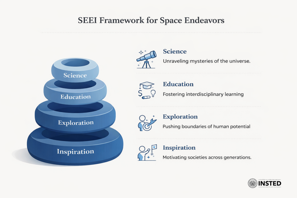
Science, Education, Exploration, and Inspiration: The Strategic Catalysts of Space
In the realm of space, the pillars of Science, Education, Exploration, and Inspiration (SEEI) fundamentally redefine our relationship with the cosmos. This framework emphasizes a non-extractive approach, ensuring that our endeavors in space aim to:
- Expand Knowledge (Science): The universe is a vast laboratory, offering unparalleled access to the electromagnetic spectrum and the unique conditions of microgravity. Through missions spearheaded by NASA, ESA, and collaborative platforms like the International Space Station, we unravel mysteries ranging from the origins of the universe to the intricate dynamics of Earth’s climate and biosphere.
- Build Human Capital (Education): Space is inherently interdisciplinary and fosters a culture of project-based learning. By integrating fields such as physics, engineering, data science, and ethics, we prepare future generations to tackle complex challenges. Initiatives like CubeSat programs, student-operated ground stations, and open satellite data access empower students to engage actively in the scientific process, cultivating a workforce adept at innovation and critical thinking.
- Extend Human Presence and Capability (Exploration): Exploration transcends tourism; it is about pushing the boundaries of human potential. Through lunar operations, planetary rovers, and in-situ resource utilization studies, we test our capabilities under extreme conditions. This pursuit drives advancements in robotics, autonomy, and life-support systems, expanding the horizon of what humanity can achieve.
- Motivate Societies Across Generations (Inspiration): Inspiration plays a pivotal yet often underappreciated role in our human journey. Remarkable images from missions like the Hubble Space Telescope or the James Webb Space Telescope ignite curiosity and ambition, motivating countless individuals, regardless of their background. This strategic soft power is essential—it shapes career choices, fosters national unity, attracts global collaboration, and legitimizes long-term investments in science and technology.
SEEI Framework for Space Endeavors
In essence, SEEI is not just a framework but a cohesive vision that propels civilizations towards uncharted territories. Engaging with space through these lenses cultivates a society that is not only resilient but also curious, adaptive, and oriented towards a brighter future. Without SEEI, nations risk intellectual stagnation. Embracing this ethos ensures that humanity remains ever-curious, exploring the cosmos with an unwavering spirit of discovery and a commitment to collective progress.